HIKING
Terrasses de Lavaux, Chexbres to St. Saphorin
Canton: Vaud Difficulty: Low Danger Level: Low Time: 30 minutes, 2km Cost: 7.40 CHF with a ½ pass, 14.80 CHF without.

This nearby hike is ideal for family or visitors. The vineyard paths offer a scenic view of Lake Geneva and an excellent introduction to the charming villages of the Vaud Region. It is roughly a 30 minute train ride away from the Vevey station.
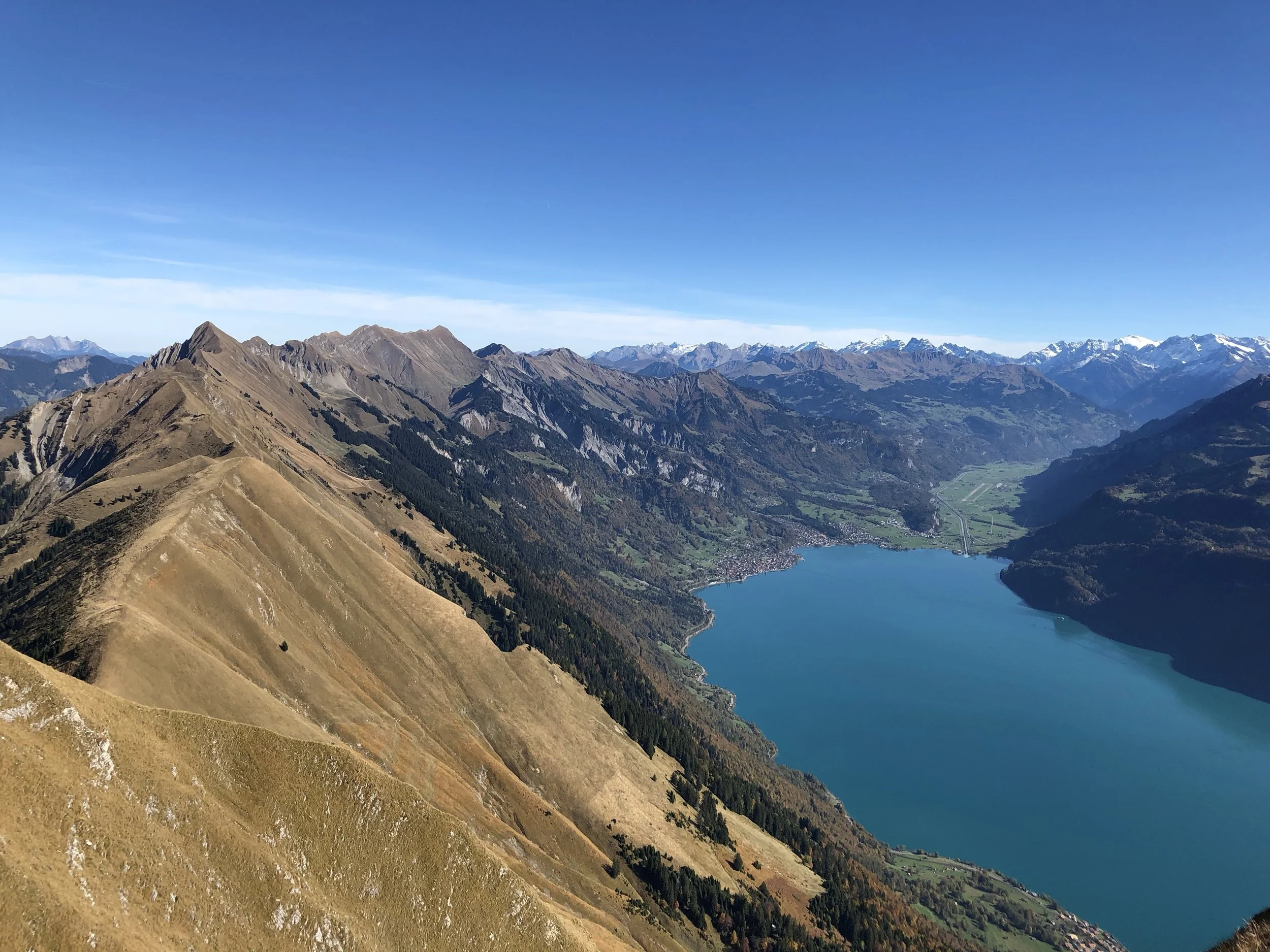
hardergrat
Canton: Bern (Interlaken) Difficulty: Very Difficult Danger Level: High, impassible in fall/winter Time: 12+ hours to hike the complete trail with multiple bailout trails along the way Cost (with 1/2 pass): approximately 80 CHF Webcam: link (Harder Klum)
Due to the potential for serious accidents, the Hardergrat trail should not be attempted when conditions are wet.
There is a reason why the Hardergrat trail is often called the "most beautiful hiking trail in the world". It is a soaring high alpine ridge trail following the knife's edge of the mountains from Interlaken to Brienz. It is a punishing trail, dangerously steep with over 8,000 feet of elevation loss and gain, and completely exposed to wind and sun beyond the Harder Klum summit. On such a steep trail, there are very few margins for mistakes and the trail becomes very dangerous when conditions are wet. The trail is often one foot wide on a two-foot-wide ridge top, and a slip off either side in many spots could mean certain injury or death. If you are going to attempt the Hardergrat trail, please discuss your trip with Switzerland Program staff to discuss weather, adequate preparation, and hazards along the way.
LES PLEIADES
Walking/snowshoeing routes
Canton: Vaud (Montreux) Difficulty: Easy Danger Level: Very low Time: Both short (1 or 2 hour) and long hikes are possible. Cost (with 1/2 pass): approximately 14 CHF Webcam: link
Les Pleiades is a beautiful nature reserve located just above Vevey/Montreux with direct train access. In the summer months, it is one of the best locations to view Switzerland's beautiful mountain wildflowers or for short scenic hikes with views of the French Alps. In the winter, Les Pleiades has short snowshoeing routes, simple ski runs ideal for learners, and cozy mountain cafés where you can grab a chocolat chaud when your hike is done.
Switzerland's beautiful white mountain flower, the Narcisscus, blooms at Les Pleiades in mid/late May. Peak times depend on seasonal temperatures, so pay attention to the weather.
dent de jaman
Canton: Vaud Difficulty: Medium difficulty Danger Level: Low; snow and ice will prevent summit access during the winter months Time: 5 to 6 hours, but can be adapted for shorter hike times. Cost (with 1/2 pass): approximately 20 CHF
It's not all about the view from the summit. The return trail down to Haut-de-Caux features some beautiful views of the lake and French Alps.
The Dent de Jaman hike has become a virtual rite of passage in the Switzerland Program, a frequent student destination, and a staff favorite.
Lauterbrunnen to Murren
Canton Bern (Interlaken) Difficulty: Medium Danger Level: Low Time: 2 hours hiking Cost: 70 CHF with a ½ pass

This hike starts near the beautiful town of Lauterbrunnen, home to waterfalls falling from depths near a kilometer high. The trail itself runs through high alpine meadows and forests, offering views of some of Switzerland’s highest mountains, including the massive Eiger, Mönch and Jungfrau peaks.
Aletsch Panoramaweg (Aletsch Glacier) Trail
Canton: Valais Difficulty: Medium Danger Level: Medium, not recommended in the winter Time: 4 hours hiking, approximately 14km Cost: 60 CHF with a ½ pass

The Aletsch Glacier is the largest glacier in the Alps. This trail will offer you breathtaking views of this massive glacier, in addition to the impressive peaks of the Aletschorn and Geisshorn.
Gorges du Triège
Canton: Valais Difficulty: Low Danger Level: Low, but closed in the winter Time: 45 minutes, 1km Cost: 36 CHF round-trip with a ½ pass

The trail through the gorge of the torrent Triège with its historical bridges redraws has all the history of the communication routes in the valley. Easily accessible, this impressive walk can be started from the village Le Trétien.
Gorges Du Dailley
Canton: Valais Difficulty: Medium Time: 2 hrs, 4km Cost: 15 CHF round-trip with a ½ pass

The majestic and exhilarating walk to the Gorges du Dailley takes you from the village of Les Granges to the Vallon de Van, through a magnificent pine forest and audacious footbridges and stairs.
Ruinaulta Sut (656.1)
Canton: Grisons Difficulty: Hard, but can be shortened Danger Level: Medium Time: 8+ hours (22.7km) Cost: 120 CHF with a ½ pass. Can be reduced with supersaver tickets

The Ruinaulta Sut trail is a loop around the Rhine Gorge, also known as the “Swiss Grand Canyon”. Located on the eastern edge of Switzerland, the Rhine River cuts a deep gorge through the mountains. The river is fast-flowing and has a beautiful pale-blue color that creates an impressive contrast with the emerald colors of the forest. Because this trail is relatively far from Château d’Hauteville, it might be worthwhile to combine this hike with a trip to Lichtenstein or Chur.